Trail Name: Wuerzlaysteig (See Comments below)
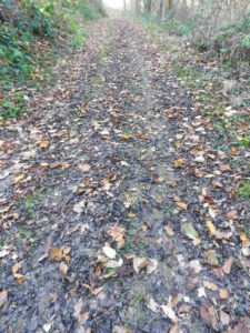
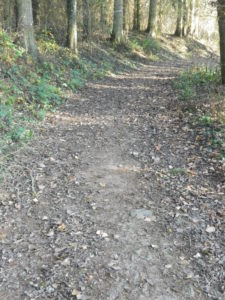
Trail Type: Middle distance; well-maintained but with very diverse surfaces along the trail; marking on the trail is good, albeit not necessarily for just one specific trail. (See Comments below)
Length:
Total – 13 kilometers/8 miles
Convenient to: Koblenz, Germany
Marking: (See Comments below as well)
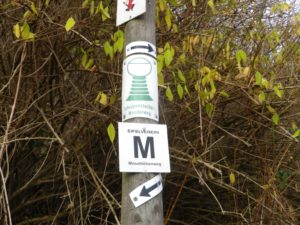
Green W on a white background (Wuerzlaysteig)
Black M on white background (Moselhoehenweg)
Green wineglass on white background (Schoppenstecherweg)
Gold/yellow rectangles superimposed, on a white background (Moselsteig)
Trail Description: In addition to steep vineyards, dramatic visuals, quiet villages, riverine majesty, and still fields and forests, this trail offers hikers a chance to experience a bit of everything the Moselle valley has to offer, while providing a fairly challenging hike (in places) for dedicated hikers.
Trailhead:
Official: Loef, train station
Mine: Lehmen: Train station, (follow Moselhoehenweg Black M on white sign to Auf der Pat)
Parking:
Public Transportation Options:
Rail: DB (DeutscheBahn) connect the villages of Loef, Kattenes and Lehmen with Koblenz or Trier, with very efficient and frequent service.
Bus: Local buses connect the riverside villages with the villages above the cliffs. Check for details online.
Suggested Stages:
Except for the Wuerzlaysteig, all the trails mentioned here are multi-stage trails. (But in this area, it is easy to complete just the Schoppenstecher or Moselhoehenweg Loef-Lehmen stage in half a day or less.) Check online sources, or the links below, for details.
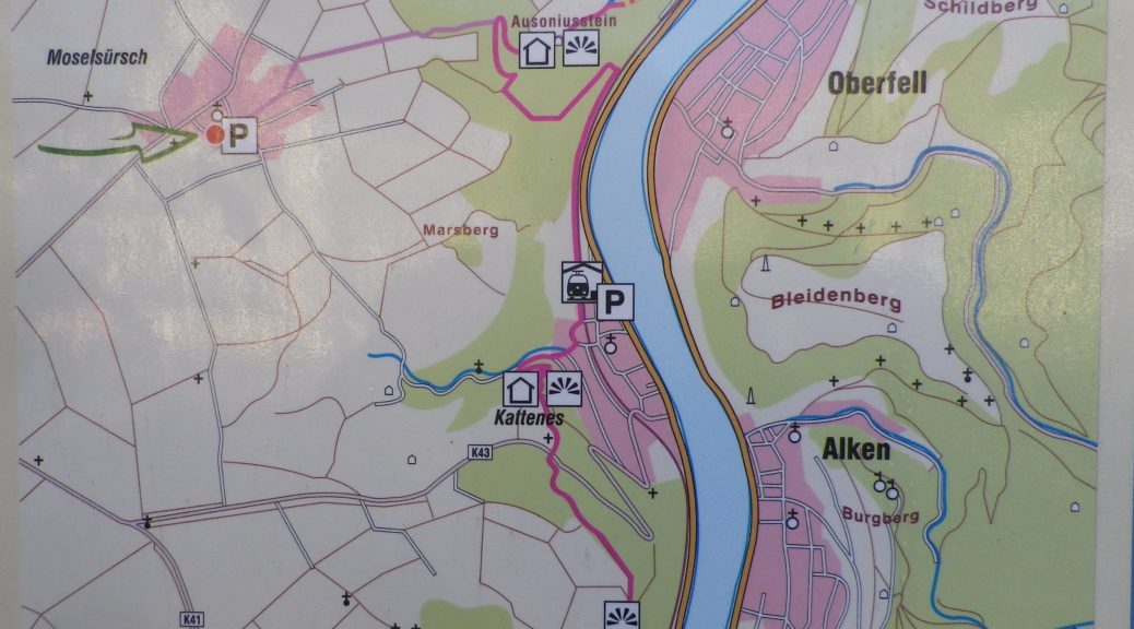
Trail Itinerary-Reference Points: (North to South)
Lehmen: Hauptstr, Auf der Pat, turn right close to end of Auf de Pat (going as far back on map to beginning of Auf der Pat), then left, follow sign to Ausoniusstein; fields, Moselsuersch: Raiffeisenstr, Moselstr; Kattenes: Muehltal, to the Kreuzweg (Way of the Cross), and most of its stations; Loef: Nachtigallenweg to the train station on Bahnhofstr
Representative Trail Photos:
Restrooms:
None observed
Attractions on or near Trail:
None specifically wine related
Tasting along the Trail:
The three villages of Lehmen, Kattenes and Loef all have wineries in them
Alternative Options:
Hiking: Any of the trails mentioned above (and below in comments) are good trails to hike.
Biking: Dedicated bicycle lanes or paths follow along the entire Moselle River Valley, forming the Mosel Radweg (Moselle Bike Trail). See the Nutshell here for my Middle Moselle ride.
Additional Information:
Regional: https://www.sonnige-untermosel.de/
Trail specific: https://www.outdooractive.com/de/route/themenweg/moseltal/wuerzlaysteig/106111146/
For partial GPX for the Schoppenstecher trail and the full section of the Moselhoehenweg trail: https://www.outdooractive.com/de/fernwanderweg/mosel-saar/moselhoehenweg-eifelseite-m-10.-etappe/23340455/
Comments:
I wanted to follow the Schoppenstecherweg, a more local trail, but information is difficult to find online, since apparently the local tourism offices now promote the 200-kilometer long Moselhoehenweg instead. But along this section of the Moselle, it is still possible to follow the Schoppenstecher signs, or the Moselhoehenweg or the Wuerzlaysteig signs in the absence of GPX.
Wuerzlaysteig and Moselhoehenweg follow the same route from Lehmen to Ausonius Stone, from where the Wuerzlaysteig goes down into Kattenes, and up Muehltal; and the Moselhoehenweg and Schoppenstecher go uphill to Moselsuersch, then down to Muehltal. They all meet again outside Kattenes’ Muehltal, at Station 12 of the Way of the Cross, where the Moselhoehenweg (as well as the Moselsteig trail, see below) continues further southward along the heights, and Wuerzlaysteig and Schoppenstecher go down into Loef, which is also an alternative for just one Moselhoehenweg section.
I spite of all the signs, I missed the Wuerzlaysteig sign by the Ausonius Stone, and ended following the Moselhoehenweg/Schoppenstecher signs up to Moselsuersch, then downhill to rejoin the Wuerzlaysteig in Kattenes’ Muehltal.
As if to confirm that this area is truly a wander paradise, from Loef, the Moselhoehenweg joins the Moselsteig, yet another very long-distance trail through the Moselle Valley, crisscrossing from one river bank to the other, all the way from Koblenz to the French border.