Trail Name: Wuerttembergischer Weinwanderweg
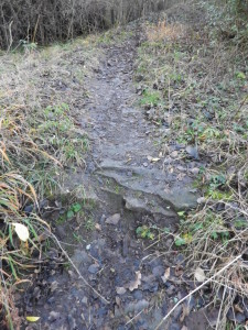
Trail Type: Long distance; often but not always paved, fairly well maintained, but the route itself is not always marked in critical places.
Length:
(Total: 470 kilometers / 292 miles)
Segments Covered in this Post: circa 27 kilometers / 17.5 miles
Convenient to: Stuttgart, Baden-Wuerttemberg, Germany
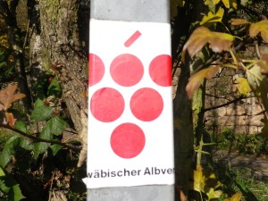
Marking: Red grape bunch on a white background (on a sign, painted on walls or trees, on stickers adhering to posts)
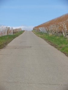
Trail Description: This trail covers a large majority of the vast viticultural areas of Wuerttemberg. It zigzags east and west, almost as much as north to south, following the state’s vineyard areas along hill and dale. In the north, it covers some of the Romantic Road villages, and in the center, the trail reaches villages less frequented by tourists. In the south, the trail passes near some major urban areas, yet the villages still seem quiet. Throughout the entire trail, the landscape varies from vineyard to forest to meadow to town, offering charming views, both near and far, on all.
Trailheads:
(Overall: Aub, Franken, Bavaria to Esslingen, Baden-Wuerttemberg.)
This post:
Remshalden- Grunbach: Bahnhof (“Train station”) – Esslingen: Marktplatz
Parking:
Remshalden: Only pay parking observed along Bahnhofstr
Rotenberg: Stettenerstr, at the top of the hill
Esslingen: Only paid parking observed
Public Transportation Options:
Rail (VVS (or Vehrkehrs-und Tarifverbund Stuttgart)):
-Grunbach/Remshalden: S2
-Stetten: None (Use S-2 to Fellbach, and bus to Stetten)
-Rotenberg and Uhlbach: None (use bus to Ober- or Unter- tuerkheim, then S1 to Stuttgart)
-Esslingen: S1 to/from downtown Stuttgart
Bus: Fellbach-Stetten and Rotenberg-Untertuerkheim
Suggested Stages:
-Grunbach/Remshalden: Bahnhof – Stetten: Rotenbergstrasse// circa 12 km / circa 8 miles
-Stetten: Rotenbergstrasse – Esslingen, Marktplatz// circa 15 km / circa 9.5 miles
Trail Itinerary-Reference Points:
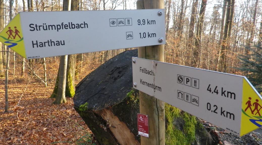
Remshalden-Grunbach: Buehlstr-Heinrich Heine Str-vineyards; Beutelsbach: Kappellbergweg-Weinsteige-vineyards/Schnait: Hochbergstr, Bachstr, vineyards and woods to Karlstein; Struempfelbach: St Urbanweg-Kelterstr, Lindenstr-Kirschbluetenweg, then follow “Fussweg nach Stetten”, vineyards/Stetten: Steigstr, Seitenstr, Rotenbergstr, vineyards, forest (following Georg-Fahrbach-Weg trail)/Kernen Turm (tower), continue following Georg-Fahrbach-Weg); Rotenberg: Park and rest area (at end of Stettenerstr), Stettenerstr-Wuerttembergstr, continue following Georg-Fahrbach-Weg; Uhlbach: Markgraeflerstr, Alte Kelter-Weinbaumuseum (museum and winebar), Herrengasse; Katharinenlinde; Ruedern: Uhlbacherstr-Hinterer Holzweg, vineyards/(Skirts above Obertuerkheim, then Mettingen, on Gayernweg)/Esslingen: Unterer Neckarhaldenweg-Neckarhaldentor, Frauenkirche, Marktplatz
Representative Trail Photo:
Restrooms:
Rotenberg: Intersection of Stettenerstr-Wuerttembergstr, opposite the bus stop, down the hill slightly, behind the old Rathaus
Esslingen: From Marktplatz/Georg-Christian-Von-Kessler-Platz, in the underpasses below Berlinerstrasse
Attractions on or near Trail:
Rotenberg: Grabkapelle Wuerttemberg, chapel-mausoleum for the Kings of Wuerttemberg, on the site of an old castle
Uhlbach: Alte Kelter Weinbaumuseum, compact but well-documented displays in this museum on viniculture in the area.
Esslingen: Two museums in the center of town detail its rich history: the Museum im Gelben Haus, and the St Dionys museum (under Marktplatz) covers archeological finds and history going back to the early middle ages. Additionally, the historic area (much of it a pedestrian zone), crisscrossed by streams and bridges, leading to narrow streets bedecked with sizeable and elegant half-timbered houses, is a delight to wander through.
Tasting along the Trail:
Weinstadt-Beutelsbach: Remstalkellerei, the area’s cooperative winery, about two blocks off the trail, on Kaiserstrasse, offering events (advanced notice), and a retail store for their products.
Rotenberg: Collegium Wirtemberg, a winery about 300 meters/yards off the trail on Wuerttembergstrasse, retail store for their products, and a nice outdoor seating area nearby a short wine education trail.
Uhlbach: Alte Kelter, a winebar offering local wines, just outside the museum hall entrance.
Untertuerkheim: Weinmanufaktur Untertuerkheim, off the trail, but also worth a visit to its shop for local products.
Esslingen: Kessler Sekt, a sparkling wine house behind the church on Marktplatz, offers tours and tastings (advanced booking required), and has a retail store for their products. Additionally, several cafes and restaurants specialize in offering local wines.
Alternative Options:
Hiking: Stuttgarter Weinwanderweg, an 11 kilometer/6.8 miles circuit beginning in Ober- or Unter-Tuerkheim. See my description at http://www.winecountrywandering.com/stuttgart-wine-trail-a-nutshell-on-the-trail/)
Running: The segment from Rotenberg to Esslingen is particularly suited for runners.
Biking: The Wuerttemberger Weinradweg, is the bike trail equivalent of this hiking trail.
Car: The Wuerttemberg Weinstrasse is a wine themed car route that covers much this same territory.
Additional Information:
Regional: http://www.tourismus-bw.de/Media/Touren/Wuerttembergischer-Weinwanderweg
Trail (segment) specific: http://regio.outdooractive.com/oar-tmbw/de/tour/fernwanderweg/wuerttembergischer-weinwanderweg/7386159/#dm=1
Comments:
Bring a good map or GPX tracks, as the trail definitely cannot be followed using the markings alone.
Some sources list this trail as only 313 kilometers (194 miles) long.