Trail Name: Itinerari Tra I Vigneti 1 (Through the Vineyards 1)
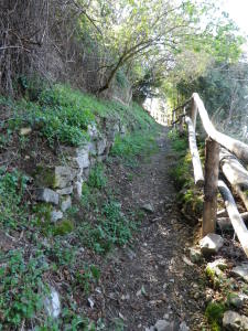
Trail Type: medium distance circuit; on asphalt in urban areas, or hard packed gravel otherwise, with a few stairs or risers in the steep areas; well maintained, and well-marked.
Length: total: 12.5 km/7.8 miles
Convenient to: Chiasso or Lugano, Switzerland; or Como, Italy
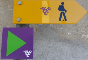
Marking: A florescent green triangle on a square purple background, with stylized white grapes in the corner. Alternatively, the same stylized grapes but in purple, on an arrow-shaped yellow marker displaying a hiker. Note: While the green triangle could indicate a mountain-bike route, I noted that following it in the absence of the yellow marker, still kept me on track with my navigation device.
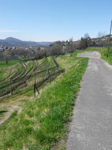
Trail Description: While starting in an urban area, this trail soon makes for the hills. As it climbs higher, it enters vineyards and villages which continue to a wood line. About a third of the way through the circuit (in Obino), the serious climbs end, and trail begins a leisurely descent, passing through more villages and vineyards, finally returning to the pedestrian zone of Mendrisio.
Trailhead: Mendrisio, Piazza del Ponte
Parking Possibilities:
Mendrisio: Somewhat problematic
-Pay parking in a garage at Largo Mario Soldini.
-Limited parking for compact (or smaller) cars on Viale alle Cantine (on the trail)
Castel San Pietro: lot near sport fields off Via Saga; spots off Via Nuree; Obino section: lot off Via Obino (on the trail);
Pay parking along some of the major streets in both towns, but watch for time limits.
Public Transportation Options:
Buses:
-Autopostale: Bus 513 has a Chiasso-Mendrisio run, taking about 30 minutes. It also stops at the hike’s midpoint in Castel San Pietro’s center.
-Autolinea Mendrisiense Line 1: from Chiasso Station (Stazione) to Mendrisio (Cantine di Sotto)
Rail: S10 (Lugano-Paradiso – Mendrisio – Chiasso) to Mendrisio takes about 22 minutes from Lugano, or 12 minutes from Chiasso.
Suggested Stages: Not applicable
Trail Itinerary-Reference Points: Clockwise
Mendrisio: Piazza del Ponte-V. San Damiano-V. Stella-V. Carlo Pasta (Rte. 2)-Viale alle Cantine-V. Carlo Maderno (Rte. 2)-Via Famiglia Maggi, path upward through wooded area-Via Generoso-Via Stradone-Via San Rocco-Via Cantine di Salorino; Salorino: Via Cantine di Salorino, past old quarry area, into woodland; Castel S. Pietro/Obino: through wooded area to base of Chiesa di Sant’ Antonino (hilltop church), Via Obino; Castel S. Pietro: Via Obino-Via alla Chiesa, cross front of church, then along grass pathway to footbridge over Via Loverciano, Via Vigino-Via Muscino; Coldrerio: Via Tognano-Via Dossello, Istituto Agrario, Via Nobili Cigalini-Via Monte Generoso; Castel San Pietro: Via Saga; Castel San Pietro/Corteglia: Via alle Corte-Via Redegonda; Mendrisio: Via della Selva-Via alla Torre, under the tower, steps down to Largo Mario Soldini, and left to Piazza del Ponte.
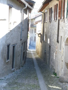
Representative Trail Photos:
Restrooms: None observed (not even pay ones).
Attractions on or near Trail:
Educational/explanation boards along the trail offering comments on local wine, history and culture throughout this hike.
Mendrisio: Some historic churches, an old town center, and the charming cantine area (with taverns and restaurants) overlooking the valley.
Tasting along the Trail:
Mendrisio: Wine bar (Enoteca) on Corso Bello (a pedestrian zone); and several wineries and taverns along Viale alle Cantine.
Corteglia: Parravicini Winery, no guaranteed hours for sales, tastings by appointment only.
Note: Hours can be limited for all the establishments above.
Alternative Options:
Walking: Itinerari Tra I Vigneti 2 or 3. (See trail link below, and select the “hiking” button for itineraries 2 and 3.)
Running: Except for a couple of short, steep passages with loose gravel or very exposed tree roots, this entire path is suitable for running.
Biking: The mountain bike circuit Route 350, the Piana del Laveggio route, covers even more of this major Ticino grape production area starting in Melano or Capolago (the “lago” being Lake Lugano), continuing to Mendrisio, Castel San Pietro, Stabio, Ligornetto, and Rancate, and returning to start. See http://www.mountainbikeland.ch/en/routes/route-0350.html
Car: None
Additional Information:
Regional: http://www.mendrisiottoturismo.ch/en/discover-the-region.html
Trail (segment) specific: http://www.mendrisiottoturismo.ch/en/free-time/outings/escursioni-a-piedi/dettaglio-escursioni.html?user_tiwebservices_pi1%5Btour_uid%5D=77&cHash=6c17d3cc8c16cee03f488d25b7dd9ccc
Comments:
This trail provides the best of two worlds: Swiss organization and efficiency developing, marking and maintaining the trail, and Italian style-food and wine to enjoy at the end of the hike.
If intent on purchasing wine, note that business hours in wineries (cantinas) and even wine bars (enotecas), can be limited, so plan ahead and check beforehand.
There are a couple of rough, steep sections on the trail to negotiate, which some might find difficult.
This trail forms two loops which offer possibilities for shortened hikes: Close to the beginning of the trail, along Via Carlo Pasta/Route 2, the trail passes Via Famiglia Maggi, and circles north on Viale alle Cantine, before returning to Via Famiglia Maggi to continue the trail south and east. Around the mid-point of the trail, another loop heads into Coldrerio off Via Vigino, returning to the Via Vigino and Via Saga intersection.
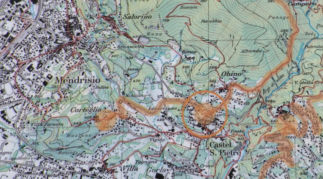
FYI: The orange line on the featured image above (the map), does not indicate the trail route. (The Itinerari Tra I Vigneti 1 route is indicated by one of the many faint red lines on the map. See the trail link above for a better map.)