Trail Name: Fraenkischer Rotwein Wanderweg (Franconian Red Wine Hiking Trail) (FRW)
Trail Type: Long-distance trail; well-maintained with a wide variety of surfaces, as well as stairs; marking on the trail rather good throughout.
Length:
Total – 79 kilometers (km)/49 miles
This segment (Last three stages): 29.5 kilometers/18.3 miles
Convenient to:
Aschaffenburg, Germany
Marking:
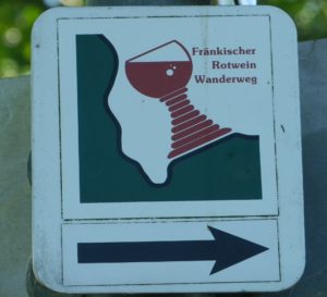
A Franconian wine glass (fat-stemmed), mostly red in color, often with the words Fraenkischer Rotwein Wanderweg, set on a green and white background on a square.
Trail Description:
This second half of the FRW starts on the right bank of the Main River, upriver from where it began. From Erlenbach am Main south, the trail has steeper inclines and more ascents and descents than the first half. Much of the trail passes through or along vineyards, and ends completely in vineyards in Buergstadt.
Trailheads:
Grosswallstadt: Am Neubergsweg, by the Sport Hotel
-Mid-point (approximate)/End of first three stages and beginning of second three stages: Erlenbach am Main – Seeweg x Mechenharderstr x Bahnstrasse
Buergstadt: Streckfussstrasse
Parking:
Erlenbach am Main: Schwimmbadweg, unimproved lots (by the pool) with many spaces, if not a popular day for swimming.
Buergstadt: Josef Ullrich Strasse (along the river), dozens of spaces
Public Transportation Options:
Rail: Deutsche Bahn (DB) operates a regional service from Aschaffenburg. Convenient though it is, the initially follows along the right bank of the river, then crosses after Erlenbach and follows along the left bank of the river, crossing back to the right bank at Miltenberg. Hence, while very convenient for this trail in places, it is not convenient in others (necessitating an extended hike, even if you can find a nearby river crossing). So, plan accordingly, study the map and be prepared to use a bus instead.
Bus: For buses as well as trains, look at the website for the Verkehrsgemeinschaft am Bayerischen Untermain (VAB) (www.vab-info.de)
Suggested Stages:
Grosswallstadt to Grossostheim: 16.2 km
Grossostheim to Elsenfeld: 17.2 km
Elsenfeld to Erlenbach: 14.9 km
Erlenbach to Klingenberg: 4.1 km (short)
Klingenberg to Grossheubach: 10.1 km
Grossheubach to Buergstadt: 15.3 km
Trail Itinerary-Reference Points: (North-South; Last three stages only)
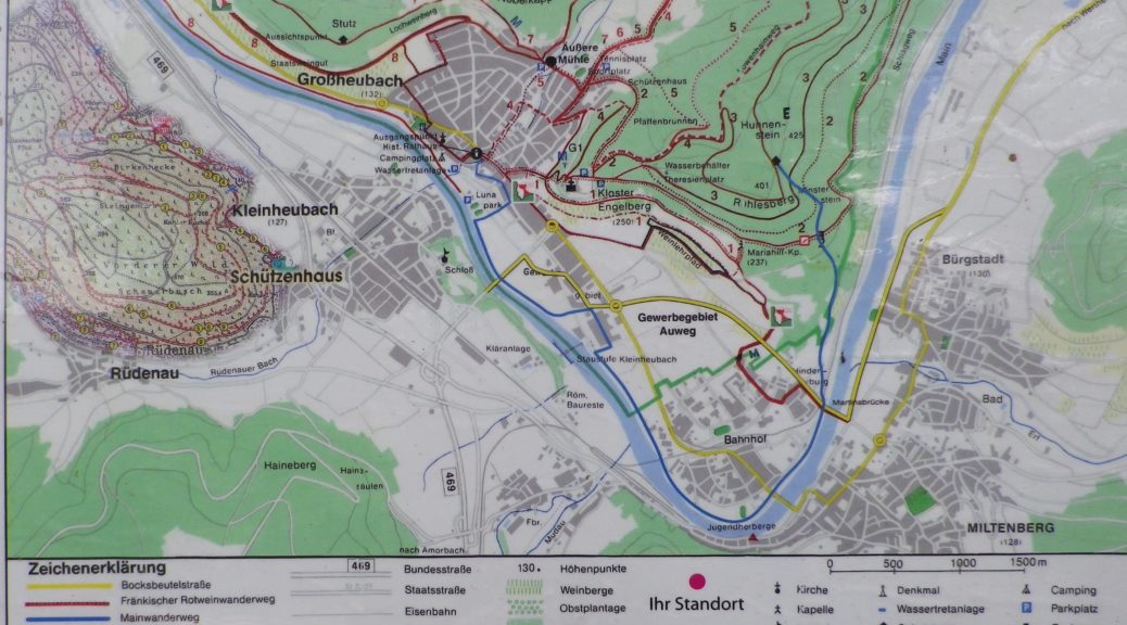
Erlenbach am Main: Mechenharder Str, Schwimmbadweg, forest to Hohbergskreuz (cross), vineyard trail, past Klingenberger Pavillon: Klingenberg: Hohbergstr, Bergwerkstr, Ludwigstr/St2309, Hauptstr, In der Altstadt, Mainstr, Wilhelmstr, up stairs (OR alternate from Lugwigstr to castle: In der Schlucht, stairs, Clingenburgstr, castle, then down right off Sonnenweg), Burgweg, Johannesweg; Klingenberg/Roellfeld: Urbanusstr, Oberlandstr, Langgasse, Gartenstr, Himmeltaler Str, turn before the cross, fields, cross creek, fields, past pond; along vines and woodline; Grossheubach: Steigweg, Fassanenallee, Fruehlingsstr, past cemetery (2 sides), Friedhofstr, Mainstr, Hauptstr, Schafgasse, Engelbergweg, Weinbergweg; Miltenberg-Nord: Cross St2309, Maria Hilf Str, Ehrlerstr, path paralleling St2309, down, and cross under RR tracks, Steingaesserstr, cross Main river; Miltenberg: Mainstr, Gartenstr, path; Buergstadt: Streckfuss, Sankt-Urbanus-Str, vineyard tractor trails; return on a higher one, past a scenic outlook stop, Centgrafenweg, Hohenlindenweg; Return to Streckfuss
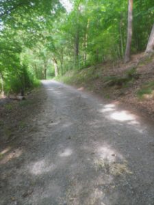
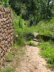
Representative Trail Photos:
Restrooms:
Klingenberg: by the castle parking lot, a small free-standing building
Grossheubach: Hofwiese x Mainstrasse
Miltenberg: Mainstr, about 350 meters downriver (southwest) from the old town Mainbruecke bridge head; Mainstr (one block from Gartenstr) in the Parkhaus Altstadt
Buergstadt: Josef-Ullrich Strasse, along the river by the bike station
Attractions on or near Trail:
Klingenberg: Weinbau und Heimat Museum, a collection of items pertaining to local viticulture and viniculture, as well as rural life in bygone days in this area.
Buergstadt: Museum Buergstadt, a collection of viticultural and vinicultural implements, as well as information on the history of wine-making in the town.
Tasting along the Trail:
Wineries may be found through this section of the trail. Additionally, several wine festivals are held in this area. Check the local tourism site for wine fests and the “Haeckerkalender” (when individual vintners host their own fests at their own wineries) for more information.
Alternative Options:
Hiking: Klingenberg’s 8-kilometer circuit trail “Ton, Steinen, und Scherben”, explores the cultural history of Klingenberg, including its vineyards.
Biking: While not wine themed, but covering many of the same towns, is the award winning Main Radweg. This 600-kilometer (almost four hundred miles) cycling itinerary follows mostly along the river, starting above Bayreuth (of operatic fame), and continuing to Mainz.
Additional Information:
Regional: https://www.churfranken.de/aktiv-kultur/fraenkischer-rotwein-wanderweg/
Trail specific: https://www.outdooractive.com/de/route/fernwanderweg/churfranken/fraenkischer-rotwein-wanderweg/1519223/
Comments:
Due to its length, there are two Nutshells, and two narrative accounts of hiking this trail to describe the full FRW. The previous Nutshell and narrative described the first three suggested stages of the trail, see here. This Nutshell itinerary (and related narrative) describe the last three suggested stages, from Erlenbach am Main upriver to Buergstadt.
Lots of road construction is underway on both sides of the river as they seek to improve roads and re-route traffic from urban centers. The trail might be slightly affected, especially around Miltenberg.