Trail Name: Entre Vignes et Vallons
Trail Type: Short distance circuit; somewhat maintained, with mostly rough surfaces, and no marking on the trail. (See comment below.)
Length:
Total – 9 or 12 kilometers/ 5.6 or 7.5 miles
Convenient to: Sancerre, France
Marking:
None
Trail Description:
While beginning (optional) in the charming historic center of Sancerre, this mostly rural trail follows through the valleys and vineyards surrounding Sancerre, over hill and dale, with very little shade, but great views of this part of central France.
Trailhead:
Sancerre: Esplanade Porte Cesar (12-kilometer version)
Sancerre: Route d’Amigny x D955 (9-kilometer version)
Parking: (Sancerre)
Rue du Marche aux Porcs, two large lots, one opposite the post office (la Poste), and one next to it.
Public Transportation Options:
Rail: Sancerre has no train station. The closest rail station is about 3.5 kilometers away, in Tracy, on the far side of the Loire River.
Bus: None observed
Suggested Stages: Not applicable
Trail Itinerary-Reference Points: (Counterclockwise)
Sancerre: R St-Andre, Rempart des Abreuvoirs, then: Allee du Treillon or Rempart des Dames, R du Serre Coeur to: traffic circle, north on D955, and just past Route d’Amigny turn onto a narrow path passing below a cemetery, past Cave de la Mignonne, vineyard Chaintres, cross Route d’Amigny, vineyards, cross D923, vineyards, cross D955/a long treelined allee, by an education panel, with grassy path to woods, straight through woods; left at D10, then right through vines to D307e to intersection with D307, left onto dirt road by telephone pole island; past Guigne-Chevres buildings, through vineyards past Chemin du Paradis, to D307 by the traffic circle, R du Serre Coeur, R Porte Vieille, to center (Place Nouvelle-Esplanade Porte Cesar).
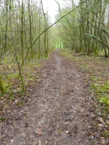
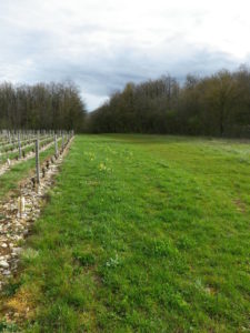
Representative Trail Photos:
Restrooms: (Sancerre)
Rue Porte Cesar (northern end), at the end of the park
Rue Porte Cesar (southern end)/Nouvelle Place, under the central structure in the middle of the square.
Attractions on or near Trail:
The Maison de Sancerre, on Rue du Meridien, is a highly informative, multi-media, interactive museum, highlighting the geological history and the wines of Sancerre. It is well worth the visit for almost any age over 10, and features a tasting for adults at the end!
Tasting along the Trail:
Several vintners operate shops with tastings in the center of Sancerre.
Alternative Options:
Hiking: The Entre Loire et Vignoble trail is a 9- kilometer long trail which provides views of the Loire, as well as the vineyards of the area.
Biking: Many mountain-biking trails, a wine themed one being the Coteaux du Sancerrois aux Bords du Loire, is listed as a 24-kilometer long, challenging trail
Car: The Route des Vignobles en Coeur de France, 170 kilometers long, covers Sancerre, Pouilly-sur-Loire, and other appellations in this region of France.
Additional Information:
Regional: http://www.tourisme-sancerre.com/ This is a great link for planning your stay in the town.
Trail specific: http://www.tourisme-sancerre.com/main.php?p=80&lang=fr This link lists three vineyard-focused trails departing the town of Sancerre.
Comments:
A nice activity for a morning in Sancerre (followed by lunch with wine, of course)