Trail Name: Bodensee Radweg (Lake Constance Bike Trail) – Untersee segment
Trail Type: long-distance, multinational cycling circuit; very well-maintained and almost exclusively paved, with excellent marking along the trail
Length:
Total – Full Bodensee Radweg is 270 kilometers/167.75 miles
Segment: Untersee circuit only is 72 kilometers/44.75 miles
Convenient to: Konstanz, Germany/Kreuzlingen, Switzerland
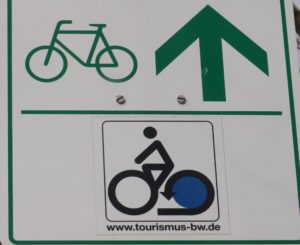
Marking: Stylized black stick figure on bike with blue rear wheel, on a white background Trail Description:
Trailhead (s): Circuit, but for ease of access to transportation and/or parking, I suggest:
Rudolfzell: Zeppelinstr
Reichenau: intersection Pirminstr/B33 (see comment below)
Parking:
Radolfzell: Zeppelinstr (by the traffic circle); Messeplatz (a large, unimproved lot)
Konstanz: No free parking observed – but lots of opportunities for paid parking. Most convenient to trail: at the airport P+R on Riedstr. (See first comment below)
Reichenau: a 30-car parking lot on northwest side of intersection Pirminstr/B33. Literally on the trail, and just meters from the northwestern edge of Konstanz. (See first comment below)
Public Transportation Options:
Rail: Konstanz/Kreuzlingen is a rail hub for the western end of Lake Constance (Bodensee), and is served by both the Deutsche Bahn and the Swiss
Ferries: While Konstanz is a main destination for ferries for all of Lake Constance, Reichenau is a hub for ferries on the Untersee, with connections to Mannenbach-Salenstein, Konstanz, Allensbach; and Gaienhofen to Steckborn or Mannenbach-Salenstein. See http://www.bsb-online.com/fahrplan-online.html
Suggested Stages:
Konstanz to Stein am Rhein (via Steckborn); to Konstanz (via Radolfzell); (then for the full circuit:) to Uberlingen; to Friedrichshafen; to Lindau or Bregenz; to Rorschach or Arbon; to Konstanz/Kreuzlingen
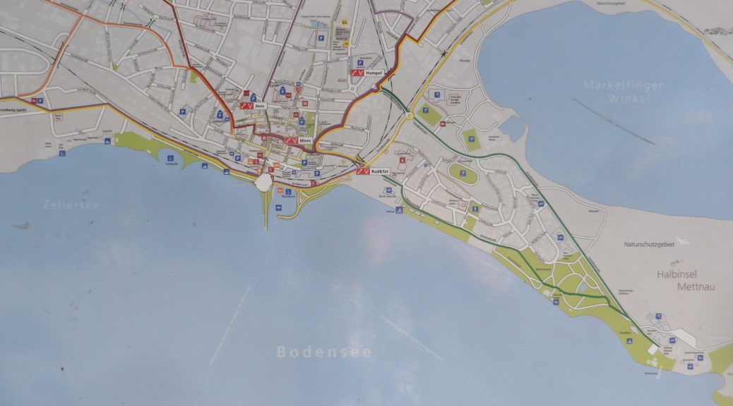
Trail Itinerary-Reference Points: (Clockwise) (Only the Untersee segment described for the rest of the Nutshell)
Reichenau causeway at B33/Pirminstr (or there about due to extensive road construction); Konstanz: B33- (or there about due to extensive road construction), Fahrradbruecke, Webersteig/Winterersteig; Gottlieben: Espenweg; Ermatigen: Riedstr-Untere Seestr, Westerfeldstr; Mannenbach-Salenstein: Seeweg, Eschlibachweg; Berlingen: Seestr; Steckborn: Seestr, Glariseggerweg; Guldifussstr to Mammern: Hauptstr, Behind Train Station, Huebackerstr; Gassa to Ober- and Unter-Eschenz: Bahnhofstr, Gassa; Bridge over Rhine; Stein am Rhein: Chirchhofplatz; Oehningen: Froschengaessle, Rheinstr, Uferweg; Stiegen; Wangen: Hauptstr; Hemmenhofen: path paralleling L192, Hauptstr; Gaienhofen: Hauptstr-Church-Im Baenkle; Hornstad: Hornstaaderstr, Hornliweg; Gundholzen: Winkelwiesen; Iznang; Moosle-Strandbadstr, Unter Eichen; Moos: Strandweg; Nature Preserve, following Radolfzellerstr; Radolfzell: Zeppelinstr, behind Train Station-Konstanzerstr; Markolfingen: Gnadenseestr, path paralleling K6170; Allensbach: Radolfzellerstr-Rathausplatz-(behind Train Station)-Strandweg; Hegne and Kloster Hegne, path along B33; Reichenau: past the causeway.
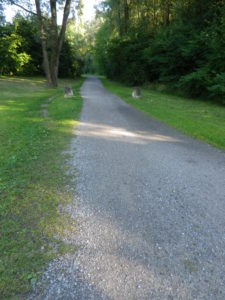
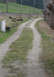
Representative Trail Photos: (Mostly asphalt, but…)
Restrooms:
Konstanz: Bahnhof, under-passage leading to harbor
Berlingen: just west of Berlingen town limits on Seestrasse, by the lakeside parking area
Steckborn: Train Station parking lot; next to the school/large parking lot, on Seestrasse
Stein am Rhein: Chirchhofplatz, next to the Kloster museum
Gaienhofen: Uferstr
Radolfzell: Marktplatz
Attractions on or near Trail:
Taegerwilen: Hermann Mueller birthhouse and bust of the botanist who developed the Mueller-Thurgau grape of international fame.
Ermatingen: Vinorama Museum, a beautiful “town” home now a museum on local wine and history
Tasting along the Trail:
In Germany: Konstanz has wine bars and the Spitalkellerei, an historic winery; and a bit off the trail in Reichenau the Winzerverein Reichenau, has good island wines, and a considerable wine history
In Switzerland: Between Triboltingen and Steckborn, there are about six small wineries, Steckborn also has a wine bar; Stein am Rhein also has a couple of wineries
Alternative Options:
Hiking: A 15.5 kilometer trail from Taegerwilen to Steckborn (alternatively called Reben und Wein, or Rebwanderweg Ermatigen, or Rebwandern am Untersee), is an easy mid-distance trail, with a return to start either by train or ferry. See the description in the Nutshell here.
Biking: A 26 kilometer circuit around Steckborn, called Gartenkunst und Besenbeiz, circles from the lake into the hills, out from and back to, Steckborn, Switzerland.
For this circuit, To shorten: Use ferries at Steckborn or Berlingen to get to Gaienhofen, or, to return to Reichenau
To lengthen: Definitely consider a ride around the island of Reichenau, for as little as 8 additional kilometers
Additional Information:
Regional: http://www.bodensee.eu/?lang=2#/en/Active/index.htm
https://www.bodenseewest.eu/de
Trail specific: https://www.bodensee-radweg.de/route/
Comments:
Construction is now underway along B33, affecting much between just south of Markelfingen to Konstanz, so be prepared for some possible re-routing/disruption to the trail, and changes in parking lots/areas described above.
If construction is still ongoing, or if cycling this trail in the summer/vacation season, cyclists arriving from the north should consider Radolfzell (the northern most point on the trail) as a base, as the traffic to Konstanz can be extremely heavy and slow in the construction zone, and during weekends and the (long) summer season.