Trail Name: Zachgraben und Weingaerten (Zach Creek and Vineyards)
Trail Type: A mid-distance circuit trail; some sections maintained, others rougher, with varying surfaces, from paved to mud. This circuit is not marked (See comment)
Length:
Total – 10.1 kilometers/6 miles
Convenient to: Graz, Austria
Marking:
None (See comment!)
Trail Description: A very rural trail passing along sometimes rough trails, this circuit has several ascents and descents, as it meanders through woodland and creek bottom, and passes by several vineyards. And yet it provides opportunities to visit traditional Buschenschanks (family-run seasonal wine taverns) along the way.
Trailhead:
Sankt Stefan ob Stainz, on a road identified as Kremserweg, by the sports fields
Parking:
Sankt Stefan ob Stainz, at the head of a road identified as Kremserweg, by the sports fields
Public Transportation Options:
Bus: Limited, as it appears to serve mostly school hours. See the website for the Graz-Koeflacher Bahn und Busbetrieb (GKB)
Suggested Stages:
Not applicable
Trail Itinerary-Reference Points: (Counterclockwise)
Sankt Stefan ob Stainz, on a road identified as Zachgraben Weg (follows the Lemsitz, then the Zach creek), take fork right after about 500 meters; into woods, past the Keltischer Baumkreis (a circle of young trees in a clearing), stay right, passing a small, old, aquaculture pond; Gundersdorf: cross small bridge (on the right), continuing following creek, pass under Highway A2, head right back down hill, and continue to follow along creek (crossing over red and white sign-marked bridges), cross back under A2; Head uphill to Buschenschank “Ofnerpeter”, pass between farm buildings to cross the road Vorderer Rosenhofweg, uphill and into woods onto Greitfranzweg; Buschenschank Christian Hackl to a trail through more woods downhill to Farmiweg; Grubberg: turn left at plant nursery onto Hoellerweg, follow to and through two gates (ensure you close them after you pass through!); into woods, then downhill to the Zach creek; Retrace steps back to start
Representative Trail Photos:
Restrooms:
Near the Keltischer Baumkreis there is an outhouse
Attractions on or near Trail:
None
Tasting along the Trail:
A few buschenshank (vintner-run wine taverns with seasonal or limited hours) are either directly on, or close to, the trail. Wineries also are in this area.
Alternative Options:
Hiking: The 10.5-kilometer GenussSchilchern Da circuit beginning in Gundersdorf, is almost identical to this trail.
Biking: The SchilcherTour, a 41 kilometer circuit beginning and ending in Deutschlandsberg, but centering around St Stefan ob Stainz.
Additional Information:
Regional: https://www.steiermark.com/en
Trail specific: https://www.outdooractive.com/de/route/wanderung/suedwest-steiermark/zachgraben-und-weingaerten/1493344/
Comments:
Marking for this named trail did not seem to exist; however, much of this trail followed Gundersdorf’s well-marked GenussSchilchern Da circuit. (There are several similarly named interconnected GenussSchilchern circuits, but the one I seemed to follow was the one beginning in/near Gundersdorf.)
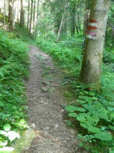
Furthermore, the GPX coordinates from the link above, while giving good general guidance on the overall course of the trail, did not always match the trails on the ground. When in doubt, follow the burgundy-colored “GenussSchilchern” signs, or the horizontal red and white bars signs.
It is advisable to stay on a trail, especially when following the creek and passing through the forest, as some of the trail, and certainly much of the surrounding area, was densely overgrown in mid-June. (For this reason, and the one below, locals advised that the best hiking conditions begin at the end of August, and run through October.)
Also, since this trail follows a creek, hikers will pass through marshy and muddy areas on some occasions.