Trail Name: Wuerttembergischer Weinwanderweg
Trail Type: Long distance; almost exclusively paved, fairly well maintained, but the route itself is not always marked in critical places.
Length:
(Total: 470 kilometers / 292 miles)
Segments Covered in this Post: 47 km / 29 miles
Convenient to: Stuttgart, Baden-Wuerttemberg, Germany
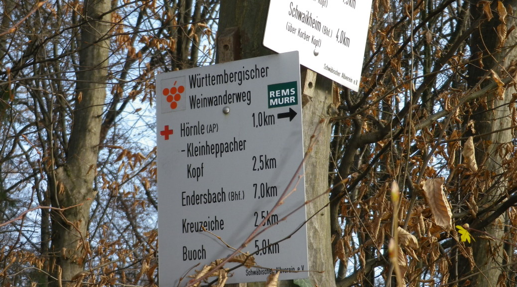
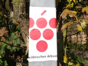
Marking: Red grape bunch on a white background (on a sign, painted on walls or trees, on stickers adhering to posts)
Trail Description: This trail covers a vast majority of the viticultural areas of Wuerttemberg. It zigzags east and west, almost as much as north to south, following the state’s vineyard areas along hill and dale. In the north, it covers some of the Romantic Road villages, and in the center, the trail reaches villages less frequented by tourists. In the south, the trail passes near some major urban areas, yet the villages still seem quiet. Throughout the entire trail, the landscape varies from vineyard to forest to meadow to town, offering charming views, both near and far, on all.
Trailheads:
(Overall: Aub, Franken, Bavaria to Esslingen, Baden-Wuerttemberg.)
This post:
Marbach am Neckar: Cottaplatz to Grunbach/Remshalden: Bahnhof (“Train station”)
Parking:
Marbach:
-P + R near train station (free only on Saturdays, Sundays, and holidays)
-Several off street parking spots by western side of Cottaplatz;
-By the footbridge over the Neckar (intersection L1100 and Bottwartalstr)
Affalterbach:
-Lemberg Hill area: large parking lot on the hill (ideal for hikers)
-Parking lot: Marbacherstr
Winnenden: P+R near train station: free on Saturday, Sunday or holidays only (otherwise pay parking on weekdays)
Remshalden: Only pay parking observed along Bahnhofstr
Public Transportation Options:
Rail:
Marbach: S-4 to/from downtown Stuttgart
Winnenden: S-3 to/from downtown Stuttgart
Grunbach/Remshalden: S-2 to/from downtown Stuttgart
Bus:
Affalterbach is served by a connecting bus from the train station at Ludwigsburg (Served by the S-5 from downtown Stuttgart)
Suggested Stages:
Marbach am Neckar: Cottaplatz – Affalterbach: Seestr// circa 16 km / circa 10 miles
Affalterbach: Seestr – Winnenden: Bahnhof// circa 13 km / circa 8 miles
Winnenden: Bahnhof – Grunbach/Remshalden: Bahnhof// circa 18 km / circa 11 miles
Trail Itinerary-Reference Points:
Marbach: Cottaplatz-Niklastorstr, Ludwigsburgerstr, footpath downhill to the Neckar footbridge, and following upriver, along river and then along the ridgeline overlooking the river; Hoheneck Cemetery (Friedhof), along the Neckar River, Marbacherstrasse bridge to Neckarweihingen: Lechtstr-Steinmauerweg, through vineyards above the river; Poppenweiler: Luginsland-Hintere Str, Kelterplatz-Affaltersbacherstr-Grasigerweg to the Lemberg Hill; Affalterbach: Lembergweg-Seestr-Beckentalweg, Sports fields, through woods; Wolfsoelden: Bus stop on Hauptstr, Hagaecker; Buchenbachtal (valley along the Buchenbach creek); Steinaechle to water treatment facility; Gollenhof: Gollenholzweg, Panoramastr, Bruehlstr, fields; Leutenbach: Sportplatz, Walkmuehlenstr-Bachstr, Seestr; Winnenden: Alfred-Kaercher Strasse-Bahnhof-Bahnhofstr-Ringstr-Schlossstr, along creek, past schools to Albertvillerstr, out of town through fields; Hanweiler: Rieslingstr-Trollingerstr (past cemetery); along vineyard-wood line, through woods, along vineyard-wood line, around (not over) Hoernle Kopf peak, along Georg Fahrbach-Weg, rest area with picnic tables, through woods to Gundelsbach: Buocherweg, through vineyards; Grunbach: Lindenstr-Kirchplatz-Schillerstr-Bahnhofstr
Representative Trail Photos:
Restrooms:
Marbach: Train station; and Rathaus, during business hours only,
Winnenden: Rathaus, during business hours only
Attractions on or near Trail:
Marbach: historic town center, with museums dedicated to chronicling German literature and authors
Affalterbach: Lemberg Hill: interesting geological formation and explanation boards (in German); Nice views over the Neckar valley area.
Tasting along the Trail:
Multiple options in taverns and restaurants in towns
Alternative Options:
Biking: The Wuerttemberger Weinradweg, is the bike trail equivalent of this hiking trail
Car: The Wuerttemberg Weinstrasse is a wine themed car route that covers much this same territory.
Additional Information:
Regional: http://www.tourismus-bw.de/Media/Touren/Wuerttembergischer-Weinwanderweg
Trail (segment) specific: http://regio.outdooractive.com/oar-tmbw/de/tour/fernwanderweg/wuerttembergischer-weinwanderweg/7386159/#dm=1
Comments:
Bring a good map or GPX tracks, as the trail definitely cannot be followed using the markings alone.
Some sources list this trail as only 313 kilometers (194 miles) long.