Trail Name: Vignes de l’Enclave des Papes, (AKA: Circuit 12, Circuit Est)
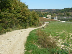
Trail Type: A medium distance circuit, along almost exclusively paved or hard-packed surfaces; fairly well maintained, with generic signage.
Length: 10 kilometers/6 miles
Convenient to: Valreas, Vaucluse Department, Provence Region, France
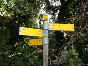
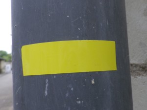
Marking: Yellow signs on a post, and yellow rectangles (Not exclusive to this particular trail)
Trail Description: A pleasant, easy hike through the pretty and arch-typical Provencal area around Visan; showcasing the varied landscape (vines, fields, olive groves, woods), with gentle inclines offering distant views, and only one slightly challenging descent.
Trailhead: Visan, Place de la Coconniere (Near Porte Saint Martin on Avenue des Allies)
Parking: Place de la Coconniere, or Place Hubert II (a large lot by the Chateau)
Public Transportation Options: None observed
Suggested Stages: Not Applicable
Trail Itinerary-Reference Points: (Counterclockwise)
Visan: Porte du Puy Barret/Place de la Bascule, D20/Route de Vaison-Chemin de Saint Roman-Chemin du Deves, olive grove; “Monnier” sign post, follow to “Combauche” sign post on D20/Route de Vaison, follow to “Ruisseau de Cubert” sign post on the Chemin du Rastelet, at the “Ruisseau de Cubert” sign post, uphill and through woods to “Bois du Cubert Haut” sign post, then following toward “Charpene” along the tarmacked Chemin de la Carne, then toward Visan. About 600 meters after the 90 degree left turn of Chemin de la Carne, turn right by an angled yellow rectangle sign and a low wooden sign “Chemin du Collet”, briefly following a rough path through trees downhill, ultimately onto the hardpacked surface of the road (Chemin du Collet), and back into Visan.
Representative Trail Photo:
Restrooms: Visan, Place de la Coconniere
Attractions on or near Trail:
Visan has an attractive old center behind its old walls, with historic sign markings on many buildings.
Tasting along the Trail:
A couple of wineries on the trail, plus several throughout the town territory.
Alternative Options:
Hiking: Circuit 11/Circuit Nord (on the maps described below), shares part of this trail (from Chemin de la Carne, and along Chemin du Collet back to town), but is only 5 kilometers long.
Running: Except for a short, narrow, steep descent, this whole trail is suitable for running
Biking (and car): The Tour de l’Enclave a la Decouverte des 4 Villages, covers the villages and countryside of Visan, Valreas, Richerenches and Grillon, along 35 kilometers of mostly backroads.
Additional Information:
Regional: http://www.dromeprovencale.fr/
Trail (segment) specific: http://www.provenceguide.com/itineraires-touristiques/enclave-des-papes/circuit-pedestre—les-vignes-de-lenclave-des-papes/provence-ITIPAC084CDT0000105-1.html
Comments:
First stop: the Syndicat d’Initiative next to the town hall (mairie) in old Visan. The staff are extremely helpful, and provide a wonderful set of free topographic maps outlining 18 circuits for hiking throughout the rather extensive town territory. The set also includes much shorter circuits for discovering the hidden gems of old Visan, and other nearby towns (Richerenches, Valreas, Grillon). They also have good information about local wineries.
Following this trail with the maps, is easy if done attentively and with faith. Follow the yellow directional arrow signs to your next destination. Knowing the name of the next destination is part of the challenge. (Monnier to Combauche to Ruisseau de Cubert to Bois du Cubert Haut…). The only other slightly tricky part was the right turn off heading down a steep path to the Chemin du Collet. (Despite the signs and map, due to the trail’s rough condition the couple hundred meters downhill, I couldn’t believe I was on a path.)