Trail Name: Fraenkischer Rotwein Wanderweg I (Franconian Red Wine Hiking Trail) (FRW)
Trail Type: Long-distance trail; well-maintained, with mixed surfaces and stairs, good marking on most of the trail, although missing in a few places.
Length:
Total – 79 kilometers/49 miles
Segment (first three stages): 48.3 kilometers/30 miles
Convenient to:
Aschaffenburg, Germany
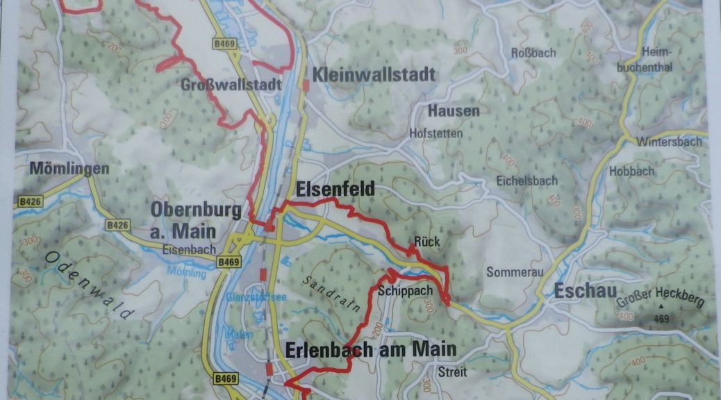
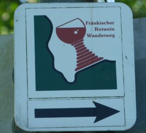
Marking:
A Franconian wine glass (fat-stemmed), mostly red in color, often with the words Fraenkischer Rotwein Wanderweg, set on a green and white background on a square.
Trail Description:
This segment of the FRW starts on the right bank of the Main River as a gentle meander north through flat river lands, before heading south into the hills on the left bank. Mixed surfaces, and a wide variety of landscapes from riverine, to field, to woods and vineyards, makes for a diverse scenic palette, and an ever-evolving hiking experience: from easy to more challenging, from sun to shade, from rural to town centers.
Trailheads:
-Start:
Official: Grosswallstadt – Am Neubergsweg, by the Sport Hotel
Mine: Grosswallstadt – Grossostheimerstr, by the Sportplatz (for parking availability)
-Mid-point/end of third stage (approximate): Erlenbach am Main – Seeweg x Mechenharderstr x Bahnstrasse
End: Buergstadt – Streckfuss
Parking:
Grosswallstadt: Am Neubergsweg, a large parking lot (some spots reserved) by the Sport Hotel; Lindenstr, unimproved areas by the sports fields; Kirchgasse, a medium-sized lot along the river
Erlenbach: Lots at Am Stadtwald, by play area; and on Geschwister-Scholl-Strasse, by the train station
Public Transportation Options:
Bus: VAB (Verkehrsgemeinschaft am Bayerischen Untermain) Line 60 connects Aschaffenburg with Grossostheim, Niedernberg, Grosswallstadt, Obernburg and Elsenfeld.
Rail: Deutsche Bahn regional trains service stations on or within 500 meters of the trail in Elsenfeld, Erlenbach am Main, Klingenberg am Main and Miltenberg
Suggested Stages:
Grosswallstadt to Grossostheim: 16.2 km
Grossostheim to Elsenfeld: 17.2 km
Elsenfeld to Erlenbach: 14.9 km
Erlenbach to Klingenberg: 4.1 km (short)
Klingenberg to Grossheubach: 10.1 km
Grossheubach to Buergstadt: 15.3 km
Trail Itinerary-Reference Points: (South to North, then south; First three stages only)
Grosswallstadt: Grossostheimerstr-Weichgasse-Hauptstr-Kirchgasse-Mainstr-path along the river; under ST 2313; Niedernberg: Leerweg path paralleling Grosswallstadterstr, ST 2313, over B469; past riding school; (Attention to the bolded instructions, as this begins a big circle around Grossostheim before returning to the same spot.) Just before Alte Ziegelei, turn left, through gate around “Reischklinge” vineyard; woods, Wendelinus chapel; vineyards, Grottenweg-Haarstallweg, through copse to Heiligekreuz chapel, back onto Haarstallweg; Grossostheim: Masspforte-Jahnstr, to Marktplatz, back out Jahnstr to Grottenweg- Sprenkelhohle, Wallstadter Weg, pass Spielmanns Alte Ziegelei, turn right at first right (same intersection above), circle around parking lot, woods; Grosswallstadt: Luetzeltal vineyards, Pilztal vineyards, Obernburg am Main: Flurbereingungsweg, woods, Hoellenstutz (rather overgrown in the summer), Jahnstr, Lindenstr-Obere Wallstr-Roemerstr-Mainstr, cross the river on the pedestrian bridge; Elsenfeld: train station, Hauptstr, Friedhofstr-Eichelsbacher Weg-Schuetzenhausstr, past Biergarten, along treeline, through woods, then vineyards, past Jesuitenberg chapel; Rueck: woodline above village, up valley above Rueck, cross Am Blumenberg; Kloster Himmelthal, cross ST 2308; Schippach: St Pius Strasse-Waldstr-Armbergsweg, woods; Erlenbach am Main: Seeweg (to Mechenharderstr x Bahnstrasse)
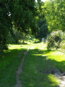
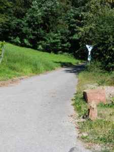
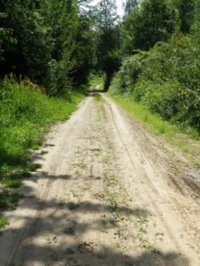
Representative Trail Photos:
Restrooms:
Grossostheim: Saw signs for it on Pfarrgasse, but did not see it.
Obernburg: behind the Rathaus on Roemerstr (if locked, ask for the key in the Rathaus)
Attractions on or near Trail:
Grossostheim: The Bachgaumuseum has a section dedicated to the viti- and vini- cultural history of Grossostheim.
Grosswallstadt: Pilztal had a small wine education trail, and Luetzeltal had about a dozen small wine tavern huts, used during wine festivals in this scenic locale.
Obernburg am Main: Although not wine-related, this former Roman fort was certainly no stranger to wine. Nowadays, both wine and interesting remains of the town’s early history are again on display in the museum.
Tasting along the Trail:
Wineries may be found throughout, but the largest concentrations are in Erlenbach and Grossostheim.
Additionally, several wine festivals are held in this area, and not just in Luetzeltal. Check the local tourism site for wine fests and the “Haeckerkalender” (when individual vintners host their own fests at the winery) for more information.
Alternative Options:
Biking: While not wine themed, but covering many of the same Churfranken towns, is the award winning Main Radweg. This 600-kilometer (almost four hundred miles) cycling itinerary covers much more as well, as it follows mostly along the river, starting above Bayreuth (of operatic fame), and continuing to Mainz.
Additional Information:
Regional: https://www.churfranken.de/aktiv-kultur/fraenkischer-rotwein-wanderweg/
Trail specific: https://www.outdooractive.com/de/route/fernwanderweg/churfranken/fraenkischer-rotwein-wanderweg/1519223/
Comments:
Having conveniently-located train stations at both ends makes doing segment three easy to return to your car at the start.