Trail Name: Urban Wine Route (Rota Urbana do Vinho)
Trail Type: Short distance, meandering walk, set in an urban environment. The route itself is not marked directionally, but does include distinctive explanation markers at many of the relevant monuments.
Length: Total: Circa 5 kilometers/ circa 3 miles
Convenient to: Porto, Portugal
Marking: Square metal plaques embedded in the sidewalk by sites on the itinerary
Trail Description:
This city walk visits 20 or so buildings or public areas which have figured significantly in the development of Porto through the Port wine trade. In so doing, it visits some of the city’s attractions, while providing a unique perspective on Porto’s history.
Trailhead:
Porto: The Municipal Hall on Avenida dos Aliados. (As an informal circuit, it can be anywhere, but I began here, as it was the “12 o’clock” point, and furthest uphill, on the circuit.)
Parking:
Rua Nova da Alfandega, a large open air lot along the river
Public Transportation Options:
Bus: Number 500 links the upper and lower parts of Porto, and passes near several trail stops
Rail: Street car circuits are in both upper and lower town
Suggested Stages: Not applicable
Trail Itinerary-Reference Points: (Listed essentially clockwise, with some zig-zags here and there)
Pacos do Concelho (Praca do Municipio x Av. dos Aliados)
Largo da Igreja de Santo Ildefonso
Palacio da Batalha (Praca da Batalha)
Muralha Fernandina (end of Rua de Augusto Rosa)
Casa da Camara (Terreiro da Se)
Ponte das Barcas (Praca da Ribeira)
Praca da Ribeira, Cais Estiva, and nearby Casa do Infante
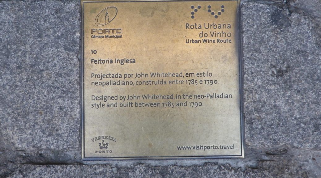
Feitoria Inglesa (Rua do Infante D. Henrique)
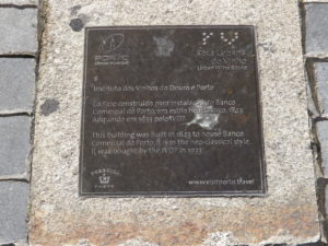
Instituto dos Vinhos do Douro e Porto (Rua Ferreira Borges)
Palacio da Bolsa (Rua Ferreira Borges)
Armazens da Companhia (Rua de Miragaia) (Now a kid-centric, interactive, thematic, museum)
Comissao de Viticultura da Regia dos Vinhos Verdes
Fonte das Virtudes (Calcada das Virtudes)
Hospital do Santo Antonio (Largo Prof. Abel Salazar)
Reitoria de Universidade (Praca Gomes Teixeira)
Cadeia e Tribunal da Relacao (Campo dos Martires da Patria)
Casa da Companhia (Rua das Flores)
Largo de Sao Domingos, Rua Mouzinho da Silveira, Rua Afonso Martins o Ahlo, Rua do Almada
(These last four are streets or squares paid for by wine taxes, and strolling along or past them will close the circuit.)
Representative Trail Photo:
Restrooms: (Small fees)
Estacao de Sao Bento
Rua do Infante D. Henrique x Rua da Reboleira
Attractions on or near Trail:
Port tasting with cellar tours. Detour to cross the river on Ponte Luis I to the lodges (cellars) of the Port companies in Vila Nova de Gaia. (Most easily accomplished between the Muralha Fernandina and Camara da Se stops on the trail itinerary listed above. Alternatively, take a water taxi from Praca da Ribeira across the river to Vila Nova de Gaia).
Museo do Vinho do Porto, on Rua de Monchique, between Armazens da Companhia and Comissao de Viticultura da Regia dos Vinhos Verdes stops along the trail.
Douro River cruises, from one hour to a few hours
Tasting along the Trail:
Plenty of wine bars to visit along the trail, and in Vila Nova several lodges offer tours and tasting.
Alternative Options: None observed
Additional Information:
Regional: http://www.visitporto.travel/Visitar/Paginas/default.aspx
Trail specific: None
Comments:
I fortuitously found references to the route online before arriving in Porto, and a brochure in a museum once in Port. However, the tourism offices could provide no information on this route, leading me to believe this was once a guided tour offering, now discontinued. Easy to do (with a good map) as a self-guided itinerary.