Trail Name: Circuit de Gargantua, also known as Circuit 1 Gargantua
Trail Type: Medium distance circuit; trail surface partly paved, otherwise grass or earthen surface (sandy or compacted); Route mostly marked.
Length:
Total: 16 kilometers/10 miles
Shortened: 9.5 kilometers/6 miles
Convenient to: Lyon, France
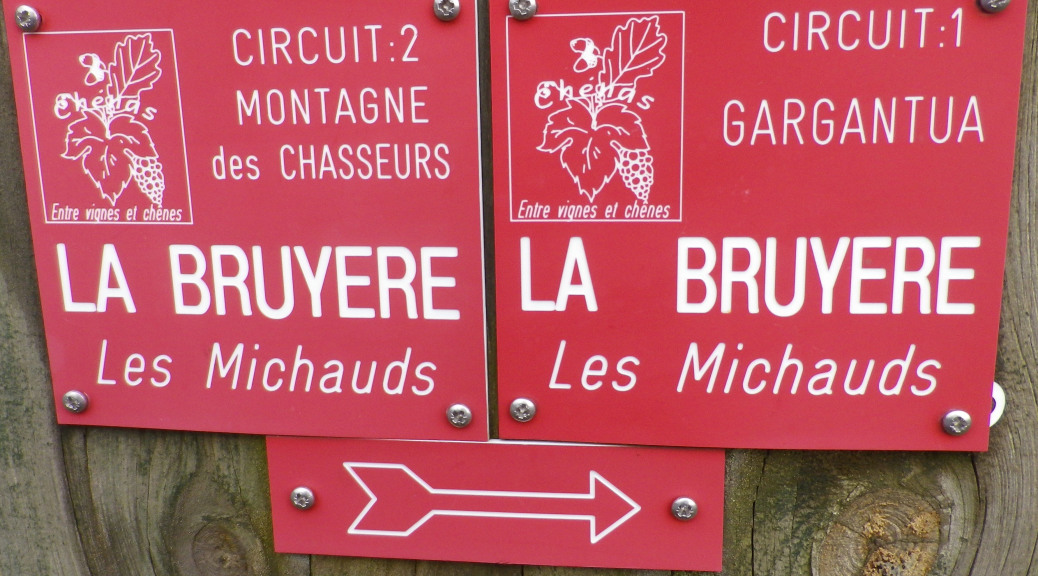
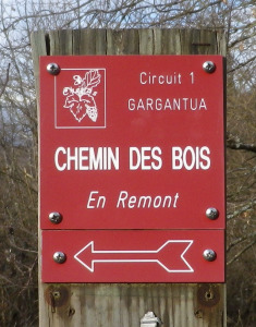
Marking: Red squares with stylized grapes and leaves, and white lettering identifying the trail name: “Circuit 1 Gargantua”, the name of the location (example: “Chemin des Bois”), and with white italic lettering below identifying the next destination (example: “En Remont”). An arrow below indicates the direction to follow.
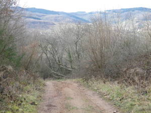
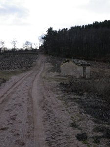
Trail Description: This trail meanders through vineyards and woods, ascending some rather steep inclines as it reaches its highlight (and highest spot), the lookout point atop the heights of Remont. Other highlights along this trail include the village and Chateau of Chenas, and the historic windmill set in the renowned Beaujolais vineyard. Other than these two little communities, this hike traverses rural areas exclusively.
Trailhead:
Official: Place de l’Eglise, Chenas
Mine: The windmill, Moulin a Vent, Romaneche-Thorins
Parking Possibilities:
Chenas: Place de l’Eglise, opposite the church entrance, a small lot (then walk about 100 meters north along D68 to join the trail); also, about 70 meters up a small street running the length of the church, another small lot on the right.
Romaneche-Thorins: D266/Le Moulin a Vent, near the windmill, a small, paved parking area for about 6 vehicles.
Public Transportation Options:
Rail: The Dijon-Macon-Lyons lines serves the Romaneche-Thorins stop, about a mile from the trail. See http://www.sncf.com/fr/gare-de-romaneche-thorins-FRHGX
Bus: Not applicable
Suggested Stages: Not applicable
Trail Itinerary-Reference Points:
Clockwise from Moulins a Vent (in Romaneche-Thorins commune): windmill, along D266, first left onto a vineyard road; Les Caves; cross D68 heading right, then turn left (just before stone marker for Louis Jadot wines) to Rochegres; head uphill following signs for Le Mont, then La Gatille; past a small hut with sign La Gatille; climb toward pines, signs for Pic de Remont; turn right into pines (along a path now being used by loggers); follow along woodland path toward La Russie; left at “Stade Georges Verne”; at a grass parking area/Chemin des Bois, head straight (downhill) toward En Remont; (Alternatively, for the shorter walk, head toward Montaigne des Chasseurs, and follow the Gargantua trail from there toward Roche Perrier as described below); walk carefully along D26 for about a kilometer/over half a mile; then turn sharply right to climb through a field and wooded area, then a vineyard, following signs for Combe Remont, Bois Retour, Montaigne des Chasseurs, (highest point) with the ruined stone house (Maison des Chasseurs); head downhill toward Roche Noire, then Roche Perrier; walk on tarmac, then a grassy path through vineyards to La Bruyere. Head toward Les Michauds past Cave du Chateau de Chenas; following road, at La Neyriat at the edge of Chenas, right onto D68 then left toward then past la Tour de Bief, cross the Bief stream, then turn left at Les Rats toward Les Maisons Neuves. Turn right onto road called Les Combes, and follow trail for Le Moulin a Vent.
Representative Trail Photos:
Restrooms:
Chenas: Caves du Chateau de Chenas
Attractions on or near Trail:
Romaneche-Thorins: Hameau Duboeuf (of the Duboeuf Beaujolais wine family), a vinicultural, viticultural and historical museum, café, and gift shop. A fun and popular stop in this area to learn about wine and wine-making, it is open for long hours, and almost every day of the year.
Romaneche-Thorins/Moulin a Vent: Chateau Portier, although mostly 19th century construction, parts of this chateau date to the 16th century, displaying the typical colorful roof tiles of the era; the chateau as well as its cellars may be visited. (Also offers snacks with the tasting, upon reservation.)
Corcelles: Chateau de Corcelles: castle visits and winery (7 kilometers away by bike or car)
Tasting along the Trail:
Chenas: Cave du Chateau de Chenas
Romaneche-Thorins/Moulin a Vent: Chateau Portier
Alternative Options:
Walking:
For shorter distance, use the identified shortcut from the hilltop picnic area (identified as Montaigne/Maison des Chasseurs) to the parking area and trail junction at La Russie.
This trail also forms part of the Sentier Victor, a 100 kilometer, 12 village trail meandering between forest and vineyards covering Chenas and other villages. See http://www.beaujolaisvignoble.com/sentier-victor.html
Running: Possible along all the trail route excepting a few very short segments of unstable or rough terrain.
Biking: With a couple of deviations, this trail also shared markings for all terrain bikes. (See Routes 2, 3, 4 and 5 in this area)
Car: Two car routes explore Chenas and Moulin a Vent areas, and more. They are the long (140 km) Route des Vins Beaujolais, and the shorter Circuit Maconnais-Beaujolais, part of the Route des Vins de Bourgogne system.
Additional Information:
Regional: For regional wine tourism ideas, see http://www.beaujolaisvignoble.com/ and http://beaujolais.com/cartographie.php?page=DT1222852935&lang=fr&codej=france&time=20120327103222
Trail (segment) specific: for a .pdf map of the trail and description select “Circuits pedestres Chenas” at http://www.beaujolaisvignoble.com/randonnees-communales.html
Comments:
This trail is part of the Entre Vignes et Chenes (Between Vines and Oaks) series of trails laid out by the village of Chenas.
Follow this circuit clockwise to maximize identifying and following the signage markings! For maximum orienteering, print out and carry the free, downloadable map of the circuit which identifies the key terrain points.
The train to/from Lyon takes about 45 minutes, stopping in Romaneche-Thorins about 3 times a day on average, so plan ahead to avoid delays or lengthy transfers.