Trail Name: Rheingauer Riesling Pfad
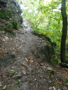
Trail Type: A long-distance hiking trail; well-maintained and with a variety of trail surfaces; marking on the trail very good.
Length:
Total – 91 kilometers/55.5 miles
Segment: about 30 kilometers/about 19 miles
Convenient to: Mainz, Wiesbaden, Germany
Marking: Yellow (or white) wine glass with a crown, on a (usually) green background
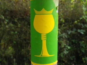
Trail Description: A mildly challenging trail through a variety of terrain, i.e. woods, fields and vineyards of the Rheingauer area, with dramatic natural river and hill scenery, romantic castle ruins and charming riverside towns on view.
Trailheads:
Kaub: Bahnstr, Train station
Ruedesheim: Niederwald Denkmal (end of my segment)
Floersheim-Wicker: Kirchstrasse
Parking:
Kaub: A couple of medium sized improved parking lots along Rheinuferstr/B42
Ruedesheim: Niederwald Denkal, a large parking lot (fee); From Rheinstrasse, along the river, up Oberstrasse and down Burgstrasse, an improved lot, and dozens of pull-in parking spots lining both the last two streets, and along neighboring Niederstrasse (some fees)
Public Transportation Options:
The Rhein-Main-Verkehrsverbund coordinate both bus and rail services in this area, with the bus serving the hinterlands, and rail serving the riverside towns. See http://www.rmv.de/de/Fahrplanauskunft/
Suggested Stages: (From here forward only refers to this segment of the trail.)
Kaub to Lorch
Lorch to Ruedesheim
Trail Itinerary-Reference Points: (North-South)
Kaub: Train Station, Bahnstr, Weinbergsweg (left fork off Bahnstr), vineyards, Schenkelbachtal; Lorchhausen: Cross the Retzbach by the top of Talweg, vineyards; Lorch: Jahnstr-Bleichstr, L3033, Marktgasse, Roemerberg, Kapellenweg, vineyards and forest; Georgs Ruh hut, cross the Spesbach creek; Assmannshausen: L3034, Niederwaldstr, Bohrenweg; Vineyards, past Binger Loch Blick (lookout station), rest station Ehrenfelsblick, vineyards and woods; Ruedesheim: Niederwalddenkmal (Off the “Am Niederwald” street)
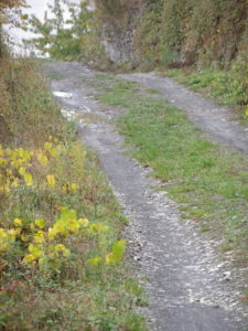
Representative Trail Photos:
Restrooms:
Kaub: Track-side, Train Station, Bahnstr; in the parking area by the underpass south of Hochstr, along Rheinufer/B42 (fee)
Lorch: Museum, Marktgasse
Ruedesheim: East and west of the Niederwald Denkmal (statue); off the trail, on Marktplatz, or along B42 (Broemserburg, or where B42 becomes Bleichstr) (fee);
Attractions on or near Trail:
Ruedesheim: The Rheingauer Wein Museum (Rhinegau Wine Museum) housed in the Broemserburg Castle is small, but provides fairly comprehensive coverage of local wine making activity, past and present.
Tasting along the Trail:
Wineries in the towns of Kaub, Lorch, Lorchhausen, Assmannshausen and Ruedesheim. Both the latter two have wine bars as well.
Alternative Options:
Walking: While not specifically wine-themed, several smaller circuit trails in Lorch, ranging from 3 to 28 kilometers, as well as several circuits in Assmannshausen, pass through vineyards and forest. Trail Numbers 1-5, 7 and 8 in Lorch cover part of this trail, and the Freiligrath trail and Romantik-Rhein route often parallel, if not follow along, this trail.
Biking: A complementary biking route exists. Look for the same wine glass signage, except in green and white only, usually associated with the ubiquitous biking directional signs (white rectangles/green lettering indicating distances to towns or famous sites.)
Car: Rheingauer Riesling Route. Again, same signage, just larger and on road signs.
Additional Information:
Regional: https://www.rheingau.de/
Trail specific: http://www.rheingau.de/sehenswertes/wanderwege/rieslingpfad
Comments:
This trail segment offers some of the most dramatic scenery I have ever experienced in Germany.
If doing online research on this trail, be aware that sometimes it is Rieslingpfad (all one word), other times Riesling Pfad. Also note that the overall distance can vary from 91 to 120 kilometers, I guess depending on a couple of alternative routes hikers can choose along the way.