Trail Name: Mosel Radweg (Moselle Bike Trail)
Trail Type: Long distance bike trail; almost exclusively paved, well maintained, well-marked.
Length:
Total: (Thionville – Koblenz) approximately 277 kilometers/172 miles
My Segment: (Bernkastel – Cochem) approximately 80 kilometers/49.75 miles
Convenient to: Trier or Koblenz, Germany
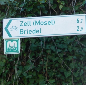
Marking: A white letter M and white bicycle icon on a square green placard
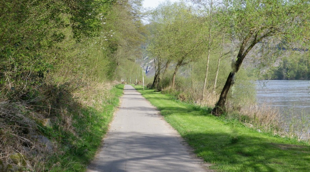
Trail Description: A famously gentle ride on mostly dedicated bike-path along the winding Moselle River, past famous vineyards, and through some well-known towns and wine villages.
Trailheads:
Official: Thionville, France, or Perl, (in Germany)/Koblenz, Germany
Mine: Bernkastel, Germany/Cochem, Germany
Parking Possibilities:
Except the bigger towns popular on tour routes, parking tends to be free, and tends to be in lots on the outskirts of a town or village, along the banks of the river.
Some of the larger parking lots on the trail, less crowded and less busy, hence more suitable for staging a day-long or even longer bike ride, were in Wolf, Enkirch, Puenderich, Briedel, and Cond (on the right bank opposite Cochem).
Public Transportation Options:
Bus: The Moselbahn, served the area from Bernkastel to Bullay, and allows for bike transport. The Verkehrsverbund Region Trier (VRT) and Verkehrsverbund Rhein-Mosel (VRM) buses also serve towns along the Mosel. Check their sites for more information.
Rail: Deutsche Bahn also covers some towns in this area (Cochem, Ediger-Eller, Neef, Bullay, Reil, Traben-Trarbach, and Urzig) and allows for bike transport.
Suggested Stages: See trail link below
Trail Itinerary-Reference Points:
Official:
Thionville-(France)-Perl (Germany)-Konz-Trier-Piesport-Bernkastel-Kues-Traben-Trarbach-Zell-Cochem-Karden-Kobern-Gondorf-Koblenz (See the trail link below for detailed information).
Mine:
Part I: Bernkastel-Kues-Graach-Zeltingen-Erden-Wolf-Traben-Trarbach-Enkirch-Burg-Reil-Punderich
Part II: Briedel-Zell-Bullay-Neef-Bremm-Eller-Nehren-Senhals-Senheim-Mesenich-Briedern-Beilstein-Bruttig-Fankel-Valwig-Cond-Cochem
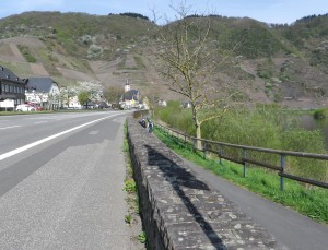
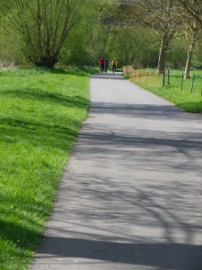
Representative Trail Photos:
Restrooms:
Bernkastel-Kues: Karlsbader Platz, in a separate building in the square behind the tourist information office.
Wolf: on Klosterbergstrasse, by the bridge overpass
Enkirch: on Brunnenplatz, by the tourist information office
Zell: on the Moselpromenade, on the downriver-side of the town, near the end of the large parking lot.
Bullay: on Am Moselufer
Bruttig: Am Moselufer, where it intersects with Klosterstrasse and the large parking lot.
Cochem: off Endertplatz, near the tourist information office.
Attractions on or near Trail:
Famous vineyards: Graach, Wehlen, Zeltingen, Urzig, Erden, Kinheim, Wolf, Zell, Bremm
Wine growing museums/artefacts: Bernkastel-Kues (St Nikolaus Hospital), Kloster Machern, Cochem,
Half-timbered look: Enkirch, Briedel, Puenderich, Cochem
Castles: Bernkastel, Traben-Trarbach, Beilstein, Cochem (Of course, these are not right on the trail, and naturally, require a climb to visit them.)
Tasting along the Trail:
Wineries, wine-bars and wine shops abound along the trail. Look for “Geoffnet” signs.
Traben-Trarbach: Traben-Trarbacher Unterwelt is a unique opportunity to tour the underground caves, and receive a glass of wine (or more tastings if booked beforehand). Sadly, only available on the last Friday of the month, at 1800.
Kloster Machern across the river from Zeltingen, has a wine bar and wine shop.
Alternative Options:
Walking:
Long-distance: Moselsteig, 365 kilometers of trail following along the heights above the river, with connecting routes down into the wine villages. The itineraries of Stages 9 and 18 (around Piesport and Cochem, respectively) would perhaps be most interesting for wine-lovers.
Short-distance: two representative circuits include the easy 7.5 kilometer Himmelreich Wanderweg in Graach, and the slightly more challenging 6.6 kilometer Uerziger Bergpfad through the Wuerzgarten vineyards in Urzig.
Short-But-Challenging: the Calmont Klettersteig (Calmont Climbing Trail), a 3 kilometer trail through the steepest vineyard in Europe, with stairs, ladders, and steep, narrow paths, offering magnificent views of the valley, and a chance to walk along the same slate that makes this wine so delicious. It starts in Eller, and ends in Bremm, and it is possible to return to Eller either via the river route, or a route along the ridgeline.
Running: This entire trail is suitable for running.
Biking: This trail has several alternatives to choose from, and may be done in shorter or longer stages.
Car: Mosel Weinstrasse, a marked car route passing through many wine villages in this region
Additional Information:
Regional: http://www.mosellandtouristik.de/en/
Trail specific: http://www.mosellandtouristik.de/en/cycling-hiking/cycling/cycle-paths/
Comments:
This nutshell focuses mostly on the entire section I cycled, and except for the trail photos, is a repeat of last month’s Nutshell.
Numerous variations or alternatives to “the” Moselradweg allow riders to switch from one to the other riverbank. Since these variations to the trail are well-marked, follow the ones suiting your itinerary. Mine followed mostly along the right bank of the Moselle, especially since the section from Zell to Neef was quieter. (The main car road along the river runs on the left bank in that section.) However, this variation had a short but steep incline on the downriver side of Bullay.
Plan your crossings ahead of time. In addition to several bridges, several ferries will take bikers on a 10 minute or so ride to the other side of the river, to explore an alternative route.
The trail from Puenderich to Bullay is perhaps the best section for families with elementary school-aged children as it is very quiet, right along the river, and very pretty.
I had read that to avoid headwinds, travel downriver. I did that and biked into the wind the whole time. Maybe a freak change of wind direction? Meanwhile, just about everyone else on the trail was heading upriver. A clue, maybe?